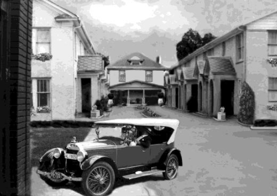
At the turn of the century of 1900 there were no striking planned residential areas around Dallas. Only a few streets were paved and those were in downtown Dallas. There were large affluent homes around City Park, in the Cedars near Ervay Street and on Maple Avenue. But no planned fashionable districts or residential parks existed.
On March 21st, 1905, Robert and Collett Munger established the building of Munger Place. To attract the right social element, Munger Place was carefully planned. Munger was just minutes from downtown Dallas by carriage. The Munger homes had to be two stories and no house could face a side street. The infrastructure featured such amenities as sidewalks, paved streets, shade trees, sewers, gas mains, and electric streetlight. Many of the Dallas leading businessmen and social elite soon called magnificent Munger Place home.
Living on the east side of the city meant that going to work downtown the sun would be behind you both coming and going. In early 1900s Swiss and Worth streets were the main street to go to town from the few new homes built in Munger Place. Main and Elm streets ended at Exposition. Main once stopped at the car barns at Main, Haskell, Peak and Elm.
In 1898 the Spanish American War caused a drill field to be established at Carroll Avenue and the street car line from Main and Elm was extended to serve the area. An artillery battalion was stationed between Main and Elm next to Carroll Avenue. After the war for some reason a cannon was moved across Carroll Avenue to the yard of a house on the southwest corner of Columbia Avenue. It lasted there facing the corner of Carroll and Columbia until the 1940s. By the early years of the new century electric streetcars replaced the horse driven ones.
Most of the Munger homes built were in the north part of the new development but the streetcars on the south side at Columbia were more convenient to go downtown. Even though Columbia was not a part of Munger Place, it slowly became important and seemed a part of it for many years.
Ruth Cooper more than any one else has told the early history of Munger Place. In 1906, six year old Ruth Cooper moved with her mother to 4826 Worth Street. Young Ruth loved the prairie of wild flowers. She and her mother would pick wild greens in the fields around her home. She remembers the city limits going to the end of her street at Fitzhugh Avenue. What is now Munger Place was a cotton patch crossed with small creeks which were tributaries of Peak Branch. The children enjoyed wading and craw fishing in the streams and a favorite place was where Peak Branch crossed Carroll Avenue at Davy Crockett School. Here you could swing from wild grapevines growing in the trees that lined the banks of the ravines.
.
A block or so south on Alcalde Street was the old swimming hole where the boys skinny-dipped but it was strictly off limits for the girls. Culverts eventually were built to cover the streams and Peak Creek. Load after load of dirt were hauled in and the school yard was leveled along with the surrounding area. The glamour and fun was lost forever.
Miss Ruth Cooper describes Munger Place at that time as a network of small creeks that ran into the Peak Branch. All underground now, still when it rains the streets are often full of water and you can see the water moving down from the high ground to the north and east.
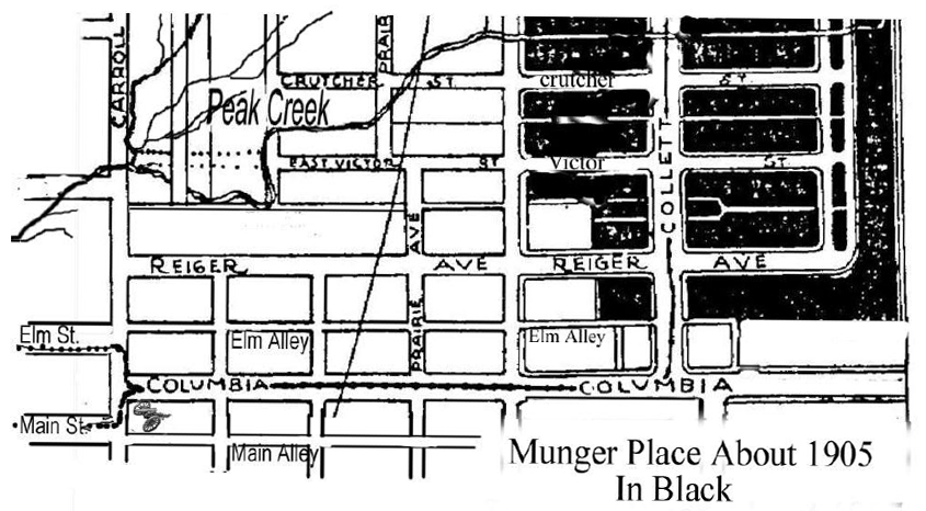
Peak Creek followed Carroll Avenue to Carroll and Victor by the Crockett School and then split at Buckner Park into several tributaries. Some moved north and one crossed the park between Crutcher (later called Tremont) and Worth streets. The stream crossed Collett just south of Worth and followed Tremont to Fitzhugh and all the way to Henderson and Junius. There were a number of trees including a giant one remembered by early residents with a great deal of endearment typical of areas with few large trees in existence. This tree was in what is now Buckner Park and was either a Pecan or a Cottonwood and possibly two great trees existed. The trees eventually died as the creek was periodically filled in blocks at a time and the water source was removed. Dallas has a long history of filling in its creeks and much of its natural beauty has died from the lack of water. Peak Creek continued to cross into the new residential development near what is now Munger Blvd. just south of Gaston and wandered across a few blocks into the hill at Junius. Even today, Junius Street has floods often coming from the hill near Lakewood. Dallas is still working to alleviate the flooding with sewers; however, this is quite expensive so the work has been slow.
In 1911, the farsighted plan of George Kessler called for a parkway to follow creeks often on both sides and the creeks could also provide water for park land. Kessler’s plan was not to fill the creeks with earth but use them to water parks or small wooded areas with streets on each side of the creeks. His plan for Dallas was in 1911 after the Munger’s preparation of the layout of Munger Place that had streets in straight blocks and not to have curving streets around creeks. If they had heard of Kessler’s plan, it is likely that they would not have followed it.
Kessler’s plan did this for Turtle Creek Parkway that is one of the beautiful places in Dallas. Kessler’s plan for Mill Creek was the same but was never implemented as the creek was neglected with trash for a long time and is now a sewer. The Mungers filled in their part of Peak Creek a little past 1910. A large culvert follows the alley between Worth and Tremont which channels the water. In an old development map, the creek can be seen channeled down the alley waiting to be filled in.
It is interesting to note that in Highland Park and University Park the developers made several parkways from the branches of Turtle Creek and these natural beauty areas contribute in part to the lasting quality of those neighborhoods. As the homes in Munger Place grew in the first decade of the new century, Columbia Avenue grew from a mud- covered street to a paved one and became convenient and accommodating in those early years when Munger Place was being developed. Milk and ice were delivered, often a vegetable wagon would come by. Many people had a cow and some raised pigs.
By 1906 the street car came down Columbia to Fitzhugh and then to Collett, another step in its many extensions. After 1906 the line was extended to Beacon and this included the Munger line on Collett Avenue. Many years later the line followed Beacon to Tremont and ended near Ridgeway. Eventually it ran to Abrams Road near the Lakewood Theater.
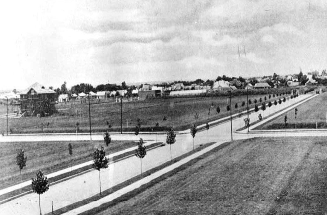
Munger Place at first was an area of paved streets in a city with few paved streets. Junius was one of the first macadamized (constructed by compacting into a solid mass a layer of small broken stone on a convex well-drained roadbed and using a binder (such as cement or asphalt) in the development and then Swiss followed. Wide sidewalks were provided with setbacks from the street and parkways were thirteen feet wide. These were lined with matching trees on each side.
“I saw Munger Place develop from a cotton patch.” said Ruth Cooper, who would roller skate on the new and then rare sidewalks. She watched with youthful enthusiasm as the workmen labored with a painstaking craftsmanship not often seen today. Little Ruth was fascinated by the carved doorways and stained glass windows and remembers most of the blocks of Swiss, Gaston and Junius. The windows of the Zintgraff home at 4927 Junius was her favorite. Construction seemed to complete the streets from north to south developing Live Oak, Swiss, Gaston, Junius, Worth, Crutcher (now Tremont), Victor and Reiger in that order. The houses were usually finished on the north side before the south side were completed, possibly because a north side location would offer afternoon shade on the southern exposure which were surrounded by the great horizontal porches.
At sometime around 1910 little Ruth Cooper heard about the Junius Heights Run that was copied after the Oklahoma Land Run of 1889. She decided to walk down a few blocks from her house on Worth street to Fitzhugh and Columbia to see what was going on. It was not on Columbia but she was determined to find out where it was being held. Ed Sullivan, a member of her church, saw her and was concerned that a nine or ten year girl was there alone. When she told him about the Junius Heights Run he knew it was a difficult place to be with people breaking their way to scramble and lay hands on others to take a homestead. He knew he would have to take her down to Columbia and then to Reiger and Beacon Street because Ruth would have gone there anyway and he could take
care of her. What they saw was a mass of people and open prairie covered with little flags. The officials shot guns for some time as people ran for their lots. That was when Junius Heights appeared. It was a rough and noisy day and Ed Sullivan took care of her and took her home.
By 1910 Columbia and Munger Place had a few businesses even as far east as Collett. Soon the street cars came to Henderson and some stores but it was just a few years before the street cars and shops came south of Junius Heights. Even though Columbia is not a part of Junius Heights it was just as helpful to Munger Place. Columbia slowly grew with more businesess and seemed a part of Junius Heights and Munger Place. for many years.
Gaston Avenue Looking West Toward Downtown In the above picture the cross street is Collett. The house in construction is the one by Zintgraft at 4927 Junius. Just to the right of the Zintgraft house is Ruth Cooper’s home at 4829 Worth. Note that only the Munger Place streets were paved as the right side of the photo shows no pavement on Gaston towards town. The picture was probably made about 1907.
Somewhere around 1906 or probably later Main and Elm entered Columbia at Carroll Ave. Few houses were on the south side of Columbia. On the north side of Columbia where Elm Street turned into Columbia there was a pharmacy on the corner and a Star Cash store was next door that sold coal, oil, feed and hay. Most everyone had a cow. Only a few stores were on Columbia at that time and it was a long way to Munger Place.
Most of the Munger homes built at that time were on the north side of Munger Place. So it was an eight block round trip walk to shop on Columbia at that time. It would be a long time for Columbia to have shops closer to Munger Place. However, the streetcar from downtown first came to Fitzhugh that was the east end of the city and then soon to Henderson when it was the city limit. The trolley on Collett made it easy to go to Columbia.
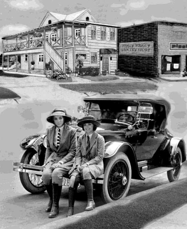
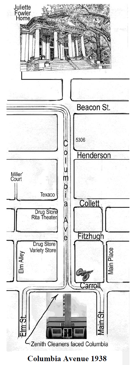
Many houses on Columbia came before those on Victor and Reiger; many were large Classic Revival homes with Greek columns. The Munger brothers planed a commercial area on Collett between Victor and Reiger. Lots were on each side of Collett facing each other. They were designated for “stores of necessities” in a book advertising the place. At 313 Collett, a Star Cash grocery opened around 1912. On the southwest side was the Green Drug store. This was the beginning of several buildings that later covered the whole block. Later the drug store moved to a new building at the corner of Collett and Columbia. This was the beginning of the Columbia and Collett corner that later was the center of activity of Columbia and Munger Place.
Columbia was at the south end of Munger Place. Reiger was the last street of Munger Place. The alley behind Reiger was the alley from Elm Street that ended at Carroll Avenue but it followed between Reiger and Columbia. This was the end of Munger Place that bordered Collett. It was called as Elm Alley and then later Centre Street. There was a Centre street in Oak Cliff so it became Elm Ally again. Then in the forties across Collett it was called Collett Place because of several nice small shops that were on the Munger side of the street.
By 1908 there were many dairies east of Beacon. Soon Beacon was the east end of Dallas and the streetcar tracks on Columbia soon ended there. The Juliette Fowler home was placed behind a dairy at the end of a hill that was before Beacon. The east end of Columbia was not paved at that time.
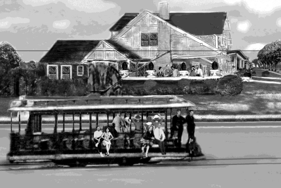
The trolley on Collett was a real luxury that enabled one to never walk any more than the length of a block to visit any store near Munger Pace or to Columbia. It may have been important as a social mixer. The car was open and easy to access enabling people to visit with their friends almost daily. With the wraparound porches along its route on Collett, the patrons could wave at neighbors from their porch. It ended at Columbia so they could transfer to the streetcar line to downtown.
Even ten years after the development of Munger Place, water often flooded the streets during rains. It was said you could see the water rushing down the high ground around St Mary’s Episcopal school near Bryan and Greenville still trying to follow the old network of creeks that once were there. For some time board walks were laid across Fitzhugh at Columbia. George Kessler’s plan for Dallas included Fitzhugh Avenue as a tree-lined boulevard that would circle the city. Ross Avenue was proposed as a tree-lined boulevard to go to the new White Rock Lake. Mill Creek Boulevard was to be on both sides of the creek like Turtle Creek. None of this was done. But if these things had been done, East Dallas and Munger Place well may have grown into beautiful neighborhoods like those Kessler planned in Kansas City. But we still had Columbia Avenue.
By 1911 White Rock Lake was built but there was so little rain it had little water; by 1912 and 1913 it slowly began to fill up. Joe Luther in the second decade made trips to the lake. He could go to the lake by Columbia that was now paved but Beacon and East Grand were too muddy so he went to Junius Street because it was graveled. Tom Frank’s bait stand on Garland Road at the dam also sold soda pop. It was worthwhile to come back to the muddy route down East Grand Avenue to stop at Tom Cole’s dairy. Mr. Cole would give kids a drink of cold milk if they would look after his cattle as they went to fish. He would come back down Beacon street that was still muddy but Columbia was now paved at Beacon. The lake without the present landscape resembled many rural lakes today. George Kessler proposed a park to surround the entire lake in his 1911 plan for Dallas. It was one of the few plans Dallas used but only until 1929.
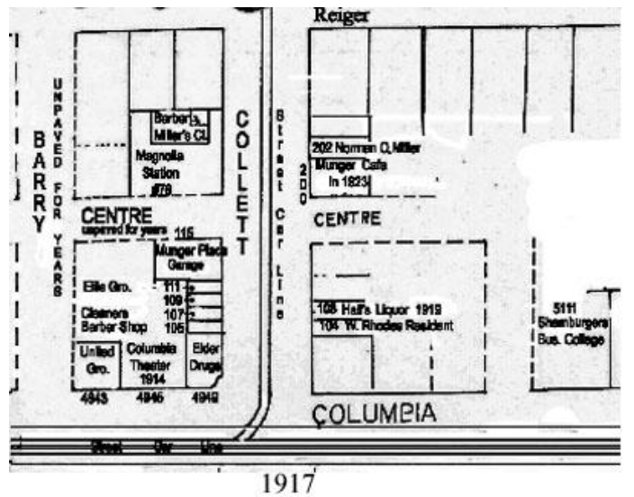
In 1914 the Columbia Theater was built at 4945 Columbia next to the pharmacy on the corner at Collett. This was the beginning of the growth on Columbia. at Collett. Stores, shops, pharmacies and cafes were coming at Columbia and Fitzhugh. Soon a gas station came on Columbia and Collett. By the time the United States entered the World War in 1917 Columbia at the Collett intersection was offering more services to its clientele. Next to the Columbia Theater at 4943 was a new grocery store. South of Munger Place an automobile garage was opened at Collett and Centre. It was called the Munger Place Garage but it was on the south side of Center. The Shamburger Business College opened at 5111 Columbia. It was an elegant building that still stands.
Columbia was developing classical buildings that blended with Munger Place. In the early twenties Norman Miller was instrumental in developing businesses in both in Munger Place and Columbia. In 1923 Miller began construction of an interesting unit of unique apartments at the end of Centre. These were the Miller Courts built in a horseshoe arrangement that added much to the now developing Columbia-Collett intersection. The Miller Courts were sixteen nice but small apartments that received a lot of attention in the neighborhood. There were eight apartments on the Munger side of Centre and eight apartments on the other. These buildings are still there.
The Ladies’ Exchange and Tea Room was one of the most interesting buildings. It was built by S J Lett in his back yard facing Collett. Lett built a large two-story restaurant with a second floor balcony. There was an entrance with French paneled doors and a tile floor. on the ground floor; there was a covered porch and shaded area for tables. The yard that surrounded the building beautifully landscaped. Business men came from downtown at lunch. Munger Place was one of the more wealthy areas of town and the tea room attracted prominent people in the city. Many of the Hockaday girls came when they could.
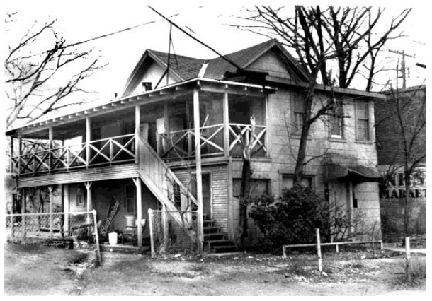
The same building in
the dark 1960s
Civic buildings, town halls, churches, schools, libraries, museums are placed where streets terminate to serve as landmarks and reinforce their importance.
Columbia was an interesting street. At the east end a hill was topped with the columned Juliette Fowler Home. On the west end of Columbia the broad avenue ended with the Zenith Cleaners that was an art deco one story building topped with a white tower rising up an other level. James Howard Kunstler, book “Home from Nowhere” has the following comment:
Shopping streets have existed for thousand of years. The human need for beauty has not changed. and civic art until recently was as conserved with beauty as it was with practicality. Ideas about beauty certainly change over time.
But the essential human hunger for beauty remains constant and we have reason to believe that is keyed to some of the fundamental ordering systems of nature, and of the human need, and place within these systems of nature and of the human need to see our place within these systems expressed in physical form.
James Kunstler