At the turn of the century a favorite Sunday afternoon drive of fashionable Dallasites was out the then elegant Ross Avenue to St. Mary’s College, located at Ross and Garrett, just west of Greenville Avenue. Ross Avenue from the red stones of the old First Baptist Church eastward was becoming a street of impressive homes. There were no beautiful residential areas around the city then as few streets were paved and grassless yards showed either the deep black gumbo earth or the umber sandy soils of South Dallas. Also, large affluent homes were located around City Park, in the Cedars near Ervay Street and on Maple Avenue, but no planned fashionable district or residential park existed.
Munger Place was born in the early years of the 20th century. On March 21, 1905, R. S. Munger announced the opening of 140 acres of land just two miles east of the Post Office as the planned residential district of Munger Place. In 1906 he purchased from Abraham Hart 100 acres of land further east. This land was adjacent to the original purchase and was reported to be sold at $800 acre according to a 1934 issue of the Dallas Journal. When the sale was completed, Mr. Munger was given a deed written on sheepskin.
East Dallas about 1990
Twenty-five year old Dallasite C. H. Munger began development of the judiciously restricted, residential district. The included area would extend from St. Mary’s Episcopal College (Ross and Garrett) on the north to the Santa Fe Railroad on the south. From east to west it would encompass the land from Fitzhugh Avenue to near the top of Junius Hill on the east. Workmen began terracing the flat open land into lots rising from one to four feet above street grades. The first stage of filling Peak Creek began. The now non-existent stream ran in close proximity to what is now Tremont Street and flowed toward Collett and Fitzhugh and crossed Carroll Avenue at Victor. It passed in front of Crockett School and ran through what became Buckner Park. As late as the early forties the low creek beds from its many tributaries were filled with gravel for riding paths in the park. It then curved around Fair Park to reach the Trinity River near today’s intersection of Hatcher and Foreman.
The time was right for a unique American style of home to replace Greek and Gothic revivals so commonplace on city streets. The Dallas News ran pictures of civic development from cities such as St. Louis, Chicago and Kansas City hoping to inspire more cultural awareness. In Chicago Frank Lloyd Wright was blending his talents with the lines and hues of the great western prairies to create the first truly American design for homes. Dallasites were reading popular home and garden magazines and were aware of the adaptations of the Louis Sullivan and Wright styles. Many were wealthy enough to desire an exclusive neighborhood and progressive enough to want a new style of dwelling.
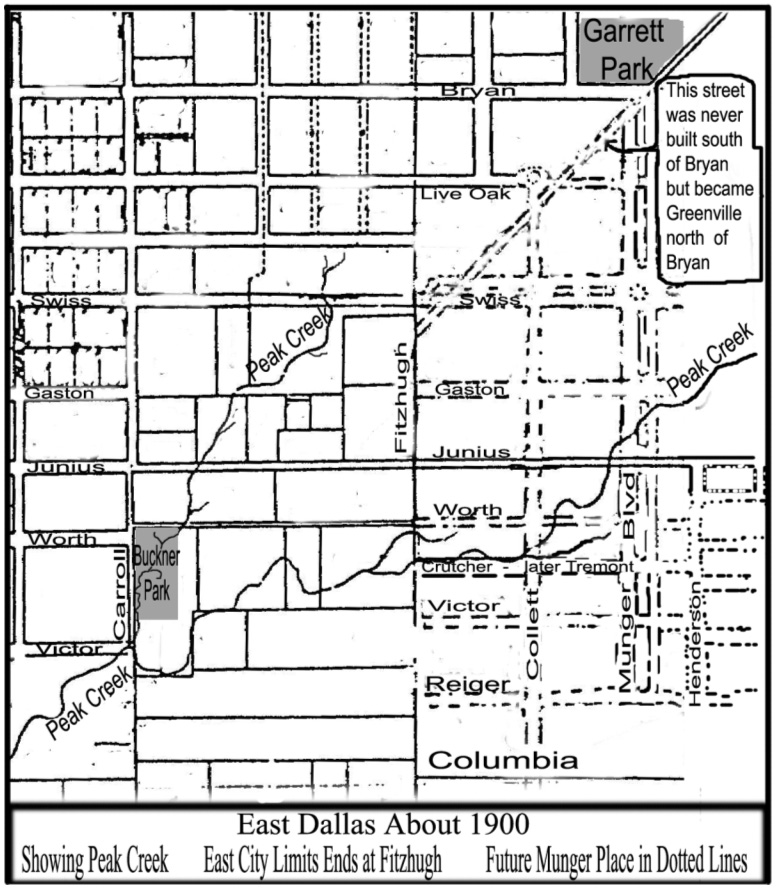
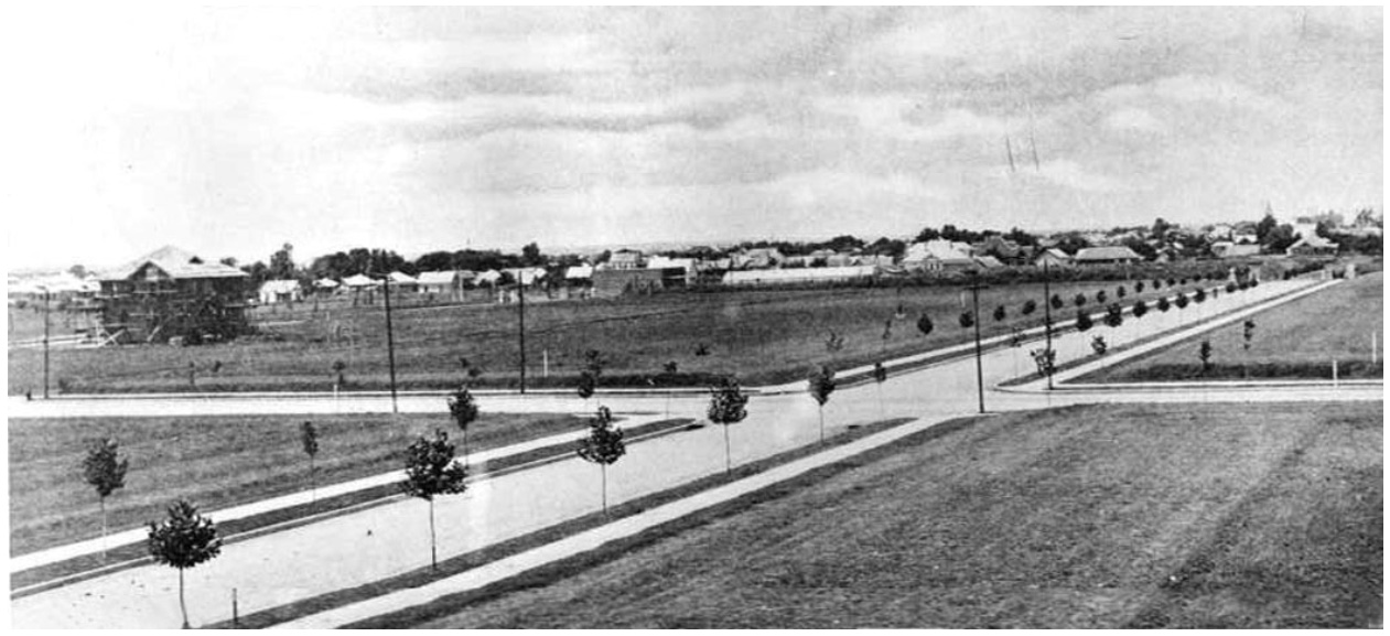
Munger Place was built on a prairie about two miles from downtown Dallas where a cotton field was segmented by many branches of a small creek. Here, in a planned neighborhood, prairie style homes with broad porches and great overhanging roofs were constructed. Although built by individual contractors and none designed by Wright, the homes bore out the Wright concept even in the painting which was not in the traditional white but in the warm earthy tones of the Texas backlands where they were built. These tones changed considerably even though few trees broke the long horizontal line of land and sky. In winter chilled by the locally named “blue northers” the land is drab and brown with a gray charcoal sky. The scene brightens up in the spring however when the greens break through after warm rains glisten on the long flat plains. The flat meadows around Dallas look their best in the spring and fall. The Munger Place homes, as originally constructed and painted, blended and complemented this landscape. The picture to the right, from the brochure advertising the development, shows the area prior to development most likely along Hawpe Lane (later Junius) that is shown on the right side in the background.
Hawpe Lane (later Junius) before Munger Place development
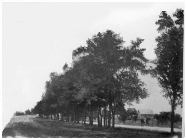
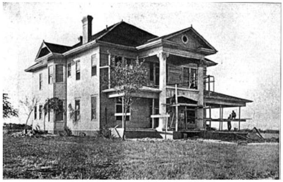
Entrance gates with stone seats were built along Fitzhugh at the intersections of Swiss, Gaston and Junius with the more elaborate on Swiss. The Baird house in the fifty-three hundred block of Swiss was most likely the first house that must have started in 1905 or 06. A. Zintgraff started the second house at 4927 Junius about 1906.
Baird House 1905-1906
4927 Junius, 1906 (Baird house in in right background)
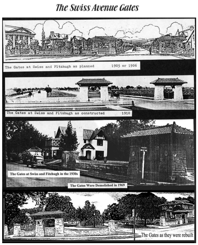
The Swiss Avenue Gates
Many Prairie Style homes followed from 1906 on. By 1910 pictures show rows of completed homes on Gaston, Junius, Worth, Tremont and Victor, with a large majority of houses built on the north-west side first. Most likely this was more desirable as the large porches would have more shade with the west sun behind them.
The following information is from some interviews with Ruth Cooper in 1978. She lived on the 4800 block of Worth Street and was born in 1900.
She said, “I saw Munger Place develop from a cotton patch”. She would roller skate on the new sidewalks to watch the building of the houses. The sidewalks were one of the few outside of downtown. Her favorite house was the one at 4927 Junius. She described the neighborhood as an open prairie with many small creeks that were tributaries of Peak Creek. People fished for crawfish at the corner of Crutcher (Tremont) and Prairie. Kids would swing from the grapevines that grew in the trees that lined the banks of the ravines. A block or so south of Victor and Alcalde was a swimming hole where the boys would skinny dip. Loads of dirt was hauled in to cover the creeks and the school yard for Crockett School. By 1910 the city put boardwalks on Fitzhugh at muddy crossing between Columbia and Crutcher.
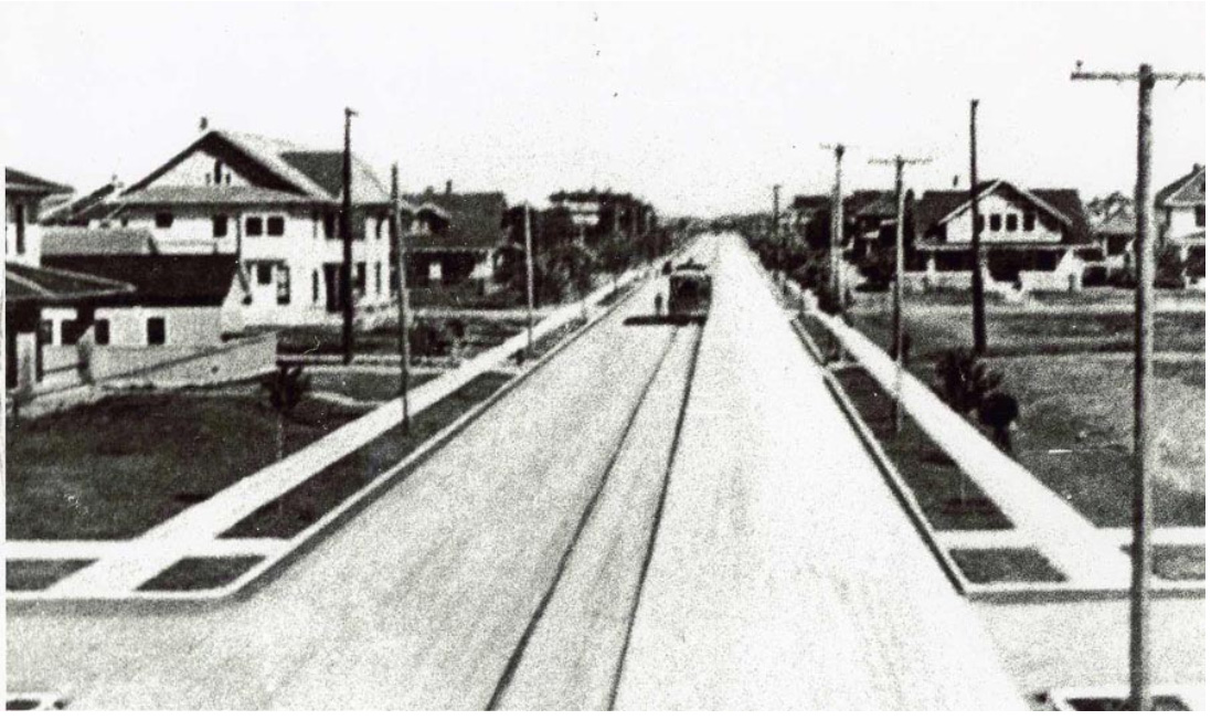
Gaston Avenue Looking West Toward Downtown (~1907)
Gaston Avenue Looking West Toward Downtown: In the above picture the cross street is Collett. The house in construction is the one by Zintgraft at 4927 Junius. Just to the right of the Zintgraft house is Ruth Cooper’s home at 4829 Worth. Note that only the Munger Place streets were paved as the right side of the photo shows no pavement on Gaston towards town. The picture was probably made about 1907.
At some time around 1910 Ruth Cooper heard about the Junius Heights Run that was copied after the Oklahoma Land Run of 1889. Little Ruth decided to walk a few blocks over to see what it was. At Fitzhugh and Reiger, Ed Sullivan, a member of her church, came by and “wondered what she was doing way down there.” When she told him he took her to see the run at what was probably Reiger and Beacon Street. What she saw was an open prairie covered with little flags. They shot guns and ran for the lots.
At that time Munger Place included streets all the way to Bryan on the north-west. According to the original plan, Swiss Avenue would end where it meets Bryan Street on the north. As the actual development occurred, it was Bryan that ended at Swiss. Bryan Street from downtown to Greenville Avenue runs from south-west to north-east but at Greenville Avenue it runs from west to east. From the original Munger Place plans the segment of Bryan from Greenville Avenue on would be called East Moreland and end at Hawpe Lane that is now named Junius.
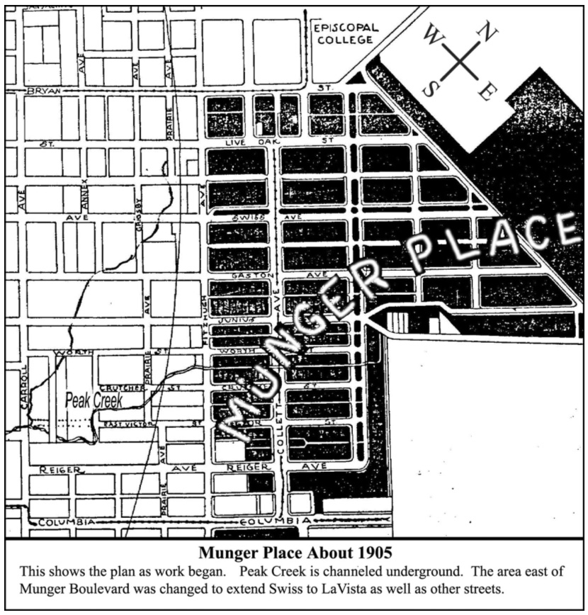
Munger Place About 1905
Of course this was not done as planned. Swiss Avenue became a boulevard with homes much more exclusive than those from Junius to Reiger. In the 1950s the so-called garden apartments wiped out many fashionable homes on Gaston but, when Swiss was threatened, it was saved by the early preservationists. They not only saved the boulevard but were helpful in saving what is now called Lower Munger Place. Swiss Avenue became an historical district which separated it from Munger Place. Munger Place later became an historical district consisting of streets from Junius to Reiger.
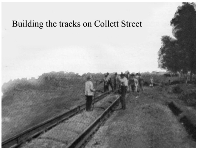
Building the tracks on Collett Street
A streetcar line ran from town to Munger Place on Columbia Avenue. At Collett a small trolley ran from Columbia north-west on Collett Street to Live Oak Avenue and back. This gave the residents access to the stores on Columbia and those on Collett as it passed neighbors sitting on the many wraparound porches on Collett.
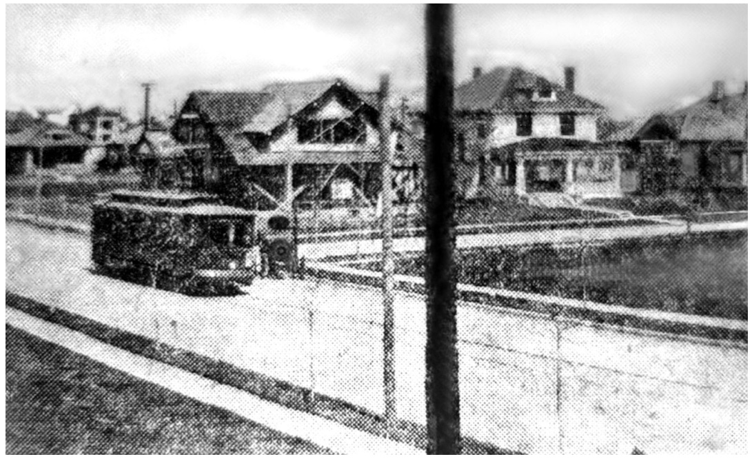
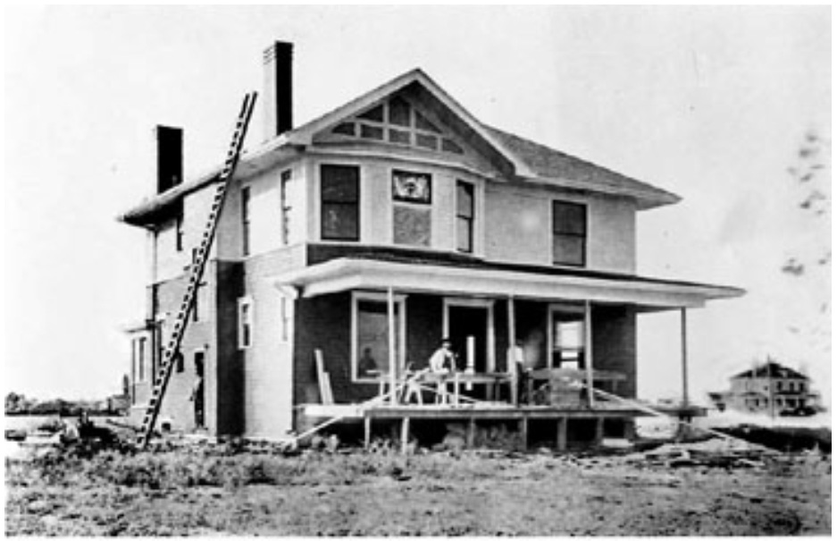
5003 Tremont House in construction (~1910)
In May of 1910 the house (5003 Tremont) that meant so much to my family, and I’m sure to the Schoellkopfs and later to Rob and Sharon Smith, was near completion. In May 1971 I was fortunate to have found and photographed a panorama view of the house in the Dallas News on file at the SMU Library before it was put on microfilm. In the May 1910 newspaper the 5003 Tremont house was still in construction and the picture shows the convenient trolley that served the neighborhood for shopping as well as access to other transit.
Collett Street looking north-west probably, a year or so after the May 1910 newspaper photo